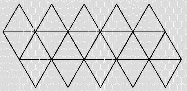
Going back to our unfolded icosahedron, we see that it is divided into three distinct bands: The row of five triangles (with separations) at the top pointing upward, the center band of ten triangles both pointing up and down, and the row of five triangles at the bottom pointing downward. The gaps in the top and bottom rows are where the triangles fold inward to touch each other, coming together at a five-sided north (and south) pole.
The center band of the unfolded icosahedron has the equator of the planet running through its middle and is bounded by the 30 degree north line of latitude at the top and the 30 degree South line of latitude at the bottom. This means that the top row of triangles runs from 30 degrees North to 90 degrees North at the tip top, with the 60 degree North line running through their middle. Similarly the bottom triangles run from 30 degrees South to the pole at 90 degrees south. Each band covers 60 degrees of latitude of the planet's surface.
How Long is that Edge?
In order to find the scale of our triangles, we need to know how long the edges are in miles (noting that each edge of each triangle is exactly the same). There are several ways to do this. The first way, is to note that the middle band contains the equator, and is as wide as five edges. Thus to find the length of a single edge, we just take the circumference of the Earth (24900 miles), and divide it by 5. This gives us an edge length of 4980 miles.
Or, if we note that the edges of the central band of triangles are at the 30 degree lines, we can calculate the circumference of the Earth at these latitudes by multiplying the circumference of Earth by the cosine of 30 degrees (about .866) and then divide by five, for an edge length of about 4313 miles.
But the main reason why I'm calculating the coordinates for the map on my own, and not simply laying hexes over an existing map is because I want the areas of land under each hex to be as equal as possible and minimize distortion. Thus the method I'm choosing to use is to make the surface area of the icosahedron equal to the surface area of the Earth, and calculate the edge lengths from the total area.
The surface area of the Earth is 196,939,900 square miles. The formula for finding the surface area of an icosahedron is 5*squareroot(3)*s^2 where s is the edge length. Going backwards, we just divide the surface area by 5*squareroot(3), then take the square root of that result. (Strangely enough, 5*squareroot(3) is 10*cosine(30) which we mentioned above.) This gives an edge length of about 4769 miles, somewhat in between the two figures given earlier.
Since we said we were going to use 50 mile wide hexes for the large scale map (allowing us to put the continental US on two sheets of hex paper side by side) I will round that edge length to a spiffy, even 4800 miles, and thus the triangle faces are 96 hexes on a side. Easy peasy.
Next time, we cover how to convert each hex on a face to grid coordinates (latitude and longitude) for looking up on Google maps.


Just popped in to say Happy 2011. Hope you're doing well.
ReplyDelete